7/8 12:01 a.m: Latest update from the Alaska Division of Forestry.
7/7 11:00 p.m.: According to Bill Was of the Talkeetna Community Emergency Response Team, the senior center was closed around 11:00 p.m. and is no longer a Red Cross evacuation center.
7/7 10:57 p.m.: We just received word from the Division of Forestry that the Level 2: Set evacuation area for the Malaspina Fire has been reduced from a five mile radius to a two mile radius. In addition, aerial efforts on the fire continued until about 10:00 pm, and ground crews have been making progress on the fire.
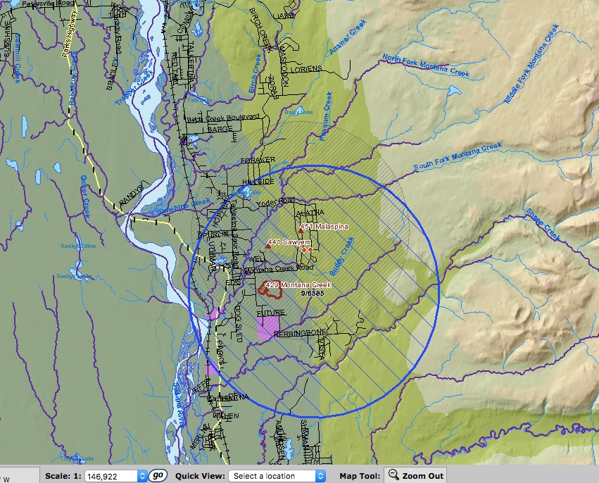
7/7 10:15 p.m.: BLM has released a map showing a 5 mile restricted flight zone (blue) and 5 mile Level 2: Set evacuation area (gray) . We’ve added the map at the bottom of this post.
7/7 10:00 p.m.: We have not received an update on the Malaspina Fire in a couple of hours. We plan to suspend updates for the day at 11 p.m., but will be back on air and online when we have more to share.
7/7 8:40: To clarify the evacuation area includes west Montana Creek Road (off Yoder Rd), Alatna Road south to Makuskin Road, and Southfork Road west to the entire South Malaspina Loop Road. A “Level 2: Set” evacuation notice has been issued for residents living within 5 miles of the “Level 3: Go” evacuation area. Level 2: Set means that residents should be ready to evacuate with little notice.
7/7 7:50 p.m.: The fire is estimated at 60 to 80 acres as of 7 p.m. Multiple air tankers were launched to drop retardant around the fire while water-scooping aircraft and helicopters are dropping water on the fire. The retardant drops have been effective and are helping slow the spread of the fire. The cause of the fire is undetermined and is under investigation.
7/7 6:35 p.m. – The Malaspina Fire burning near Talkeetna is now estimated at 60 acres. Firefighters say one structure was lost. South Malaspina Loop Road, West Montana Creek Road (off Yoder Road), Makuskin Road, and Yoder Road have all been evacuated.
7/7 6:30 p.m.: From Alaska Division of Forestry: The fire is roughly 10 acres and moving uphill. AIR DROPS are being administered by Helitac-Division of Forestry and Heavy Air Scoopers. ON THE GROUND:Hotshot and type 2IA (Initial Attack) crews are on scene. Smoke jumpers are on the way from Talkeetna Airport. JBER Taskforce is on scene.
7/7 5:19 p.m.: LEVEL 3 GO EVACUATION ORDER GIVEN BY FORESTRY.
THIS IS A MANDATORY EVACUATION has been expanded to include Makuskin and Yoder Roads, as well as South Malaspina Look and Montana Creek Road. Upper Susitna Senior Center, located at 16463 E Helena Dr, being prepared by Red Cross and CERT Team.
7/7 4:20 p.m.: Level 3:Go evacuation order has been issued for residents of Malaspina Loop and Montana Creek Drive. Shelter is available at the Upper Susitna Senior Center on 16463 E Helena Dr, being prepared by Red Cross and CERT Team.
7/7 3:30 p.m.: The new fire, called the Malaspina Fire (#451), was reported at about 3:30 p.m. and has grown to an estimated 10 acres, according to the Alaska Division of Forestry. The fire is burning in black spruce and is sending up a large column of smoke. The fire is moving north.
Forestry, Helitac and Mat-Su Borough personnel on scene now. Fire locations is at: 39022 South Malaspina loop, Sunshine, AK
From the Mat-Su Borough:
“LEVEL 3 GO EVACUATION ORDER GIVEN BY FORESTRY.
THIS IS A MANDATORY EVACUATION
Fire on Malaspina Loop is heading north.
Residents on West Montana Creek ROAD and South Malaspina loop are to evacuate to Upper Susitna Senior Center, located at 16463 E Helena Dr, being prepared by Red Cross and CERT Team as an evacuation center at this time.”